Description
GNSS Receiver CHCNAV M6 in Uzbekistan, Tashkent
Integrated with a powerful GNSS engine, the M6 performs tracking and positioning of high-end GNSS satellites. GPS, GLONASS, Galileo and BDS support the M6 seamlessly anywhere in the world.
Various modules provide the most professional and convenient RTK network solution. Bluetooth and WiFi modules provide easy and fast access in the field, even when using a smartphone for setup or downloading. The 3.75G indoor network modem offers not only the general NTRIP service, but also the CHC APIS method, such as the traditional single-base, single-rover RTK, which does not cover the NTRIP service area.
Compatible with field data collection software running on Android OS, the M6 is the best choice for a future GNSS receiver, offering more options now or in the future.
The CHCNAV M6 is a high-precision GNSS receiver designed for professional surveying, mapping, and geospatial applications. Here’s an overview of its features and capabilities:
- Multi-Constellation and Multi-Frequency Support: The M6 receiver is capable of tracking multiple satellite constellations, including GPS, GLONASS, Galileo, BeiDou, and QZSS. It also supports multiple frequencies, enabling robust and reliable positioning even in challenging environments.
- High-Precision Positioning: The M6 receiver offers centimeter-level positioning accuracy through advanced GNSS processing algorithms and correction services such as RTK (Real-Time Kinematic) and PPP (Precise Point Positioning).
- Integrated Communication Options GNSS Receiver CHCNAV M6: It features built-in communication options such as Bluetooth, Wi-Fi, and cellular connectivity, allowing for easy data transfer and communication with field controllers or surveying software.
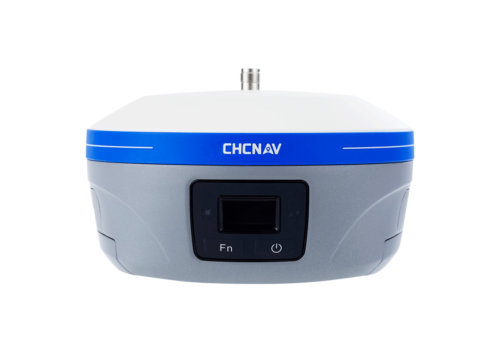
- Compact and Lightweight Design GNSS Receiver CHCNAV M6: The M6 receiver is designed to be compact and lightweight, making it easy to transport and install in the field. Its rugged construction ensures durability and reliability in various environmental conditions.
- Data Logging and Storage GNSS Receiver CHCNAV M6: The receiver has built-in data logging capabilities, allowing users to store raw GNSS observation data for post-processing and analysis. It typically supports common data formats such as RINEX (Receiver Independent Exchange Format) for compatibility with third-party software.
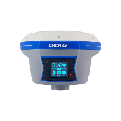
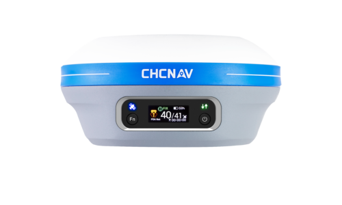
- User-Friendly Interface GNSS Receiver CHCNAV M6: The M6 receiver features an intuitive user interface with a color touchscreen display for easy configuration and operation in the field. It may also include customizable menus and shortcut buttons to streamline workflow.
- Flexible Power Options: The receiver supports various power options, including rechargeable batteries, external power sources, and solar panels, providing flexibility for extended field operations.
- Real-Time Data Corrections: The M6 receiver can receive real-time data corrections from a network of reference stations or base stations, enabling precise positioning in real-time or near real-time.
- Compatibility with Third-Party Software: It is compatible with a wide range of third-party surveying and mapping software, allowing users to integrate the M6 receiver into their existing workflows seamlessly.
- Applications: The M6 receiver is suitable for a wide range of applications, including land surveying, construction layout, GIS (Geographic Information Systems) mapping, asset management, precision agriculture, and environmental monitoring.
Other productes in category Survey and Engineering