CONTROLLER CHC HCE300

CONTROLLER CHC HCE300

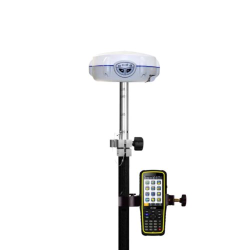
HCE300 is a professional Android field surveying controller with alphanumeric keypad which gives much flexibility to surveyors during fieldwork.

Overall, the CHC HCE300 is a versatile and reliable field controller that provides surveyors, engineers, and GIS professionals with the tools they need to efficiently collect, manage, and analyze geospatial data in the field. Its rugged design, high performance, and flexible connectivity options make it well-suited for a wide range of outdoor applications.

Tactical and technical characteristics

  • Andriod 4.4 OS supported
  • 4.3’’ sunlight readable screen
  • Perfect fit with LandStar 7 software
  • Alphanumeric keypad with backlight
  • Rugged IP67 protection from harsh environment
  • 6500 mAh battery for 10 h endurance

Description

CONTROLLER CHC HCE300 in Uzbekistan, Tashkent

As a data controller, HCE300 is powered with the rugged IP67 rating and 1.5 m fall-survival for the most demanding environment. Besides, the 6500 mAh Li-ion battery capacity can keep you working for a long time without worrying about the power supply.

Adopting variable sensors, like the barometer, NFC, noise reduction, gyro, E-compass, G-sensor, etc., HCE300 also provides Bluetooth, WiFi, dual SIM and dual standby features.

Compatible with field data collection software running on Android OS, HCE300 is the solution for a future­proof GNSS data controller, offering you more options at present or in the future.

The CHC HCE300 is a rugged and versatile field controller designed for use in surveying, construction, GIS (Geographic Information Systems), and other geospatial applications. Here’s an overview of its features and capabilities:

  1. Rugged Design CONTROLLER CHC HCE300: The HCE300 is built to withstand harsh outdoor environments, featuring a rugged and durable construction that is resistant to water, dust, and shock. This makes it suitable for use in demanding field conditions.
  2. Large Touchscreen Display CONTROLLER CHC HCE300: The controller is equipped with a large touchscreen display, typically ranging from 5 to 7 inches in size, providing a clear and intuitive interface for data collection, navigation, and operation of surveying instruments.
  3. High Performance CONTROLLER CHC HCE300: Powered by a fast and efficient processor, the HCE300 delivers high performance for running complex surveying and mapping software, processing large datasets, and performing real-time calculations in the field.
  4. Integrated GNSS Receiver: Some versions of the HCE300 may include an integrated GNSS receiver, allowing it to function as a standalone positioning device for navigation and data collection tasks.
  5. Connectivity Options: The controller offers a range of connectivity options, including Bluetooth, Wi-Fi, USB, and serial ports, for seamless communication with surveying instruments, GNSS receivers, external sensors, and data storage devices.
  6. Long Battery Life CONTROLLER CHC HCE300: With a high-capacity battery, the HCE300 provides long-lasting power for extended fieldwork sessions, minimizing downtime and increasing productivity in the field.
  7. Flexible Mounting Options: The controller may feature various mounting options, such as hand straps, shoulder straps, and pole mounts, allowing users to carry or mount the device in a convenient and ergonomic manner.
  8. Customizable Software: CHC provides customizable software options for the HCE300, allowing users to tailor the interface and functionality to their specific requirements. This may include support for third-party surveying and GIS software, as well as custom applications developed by CHC or third-party developers.
  9. Data Collection and Processing: The controller facilitates data collection and processing tasks, including point collection, stakeout, offset measurement, line and area calculation, and data management. It typically supports common data formats for compatibility with various surveying instruments and software.
  10. User-Friendly Interface: The HCE300 features an intuitive and user-friendly interface designed to streamline fieldwork operations and minimize the learning curve for new users. It may include customizable menus, toolbars, and shortcut buttons for easy access to commonly used functions.
Other productes in category  Без категории