LexxiT1660

LexxiT1660

Overall, the Lexxi T1660 is a powerful and versatile tool for utility locating and mapping, providing users with accurate and detailed information about underground utilities and structures. Its advanced GPR technology, real-time data acquisition, and user-friendly interface make it an essential asset for professionals involved in utility management and infrastructure projects.

Category:

Technical characteristics

Location ranges (nominal): 7, 15, 30, 60, 120, 250, 500, 1000, 2000, 3000, 6000 m
Accuracy: ± 1% of range
Resolution: ± 1% of range
Distribution speed: Varies from 0.2 to 0.99
The last number used is automatically remembered
Gain: Automatic vertical
Pulse parameters:
Duration: From 3 nsec to 3 msec, selectable according to range
Amplitude: 5 V nominal no load
Output impedance: 25 Ω, 50 Ω, 75 Ω, 100 Ω; selectable by switch
Balance adjustments: Not required
Exit:
Connection connectors: 2 x 4 mm at 19 mm height
Protection: The device does not fail when a voltage of 250 V (rms) AC is applied to its input. However, for safety reasons you should NOT operate under these conditions. To ensure safe use of the instrument, a test lead with a safety blocking filter MUST be used when testing live cables.
Display:
Type: Color LCD with backlight, resolution 328 x 256 pixels, size 3.5 inches
Cursor: One vertical line
Modes (real time): Trace a single line
Selecting the cable type (setting the propagation speed, default gain algorithm and impedance value)
Screen contrast with automatic temperature compensation
Setting the propagation speed
Food: 6 LR6 alkaline AA batteries
Operating temperature: From -20°С to +50°С
Storage temperature: From -30°С to +70°С
Relative humidity: 93% at +40°C
Protection level: IP54
Dimensions: 250 x 100 x 55 mm
Weight: 600 g (including batteries, no wires)

Description

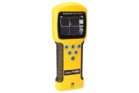
LexxiT1660 in Uzbekistan, Tashkent

Radiodetection’s Lexxi T1660 provides an unrivaled combination of performance, ease of use and cost-effectiveness. Radiodetection has created the Lexxi T1660 by taking the easy-to-use ergonomics familiar to users of the Riser Bond Model 1550 and Bicotest Lexxi T810 and incorporating a unique TDR motor and 3.5-inch backlit color display.

The Lexxi T1660 is a specialized utility locating and mapping device designed for accurately detecting and tracing underground utilities such as pipes, cables, and conduits. Here’s an overview of its features and functionality:

  1. Ground Penetrating Radar (GPR) Technology: The Lexxi T1660 utilizes advanced Ground Penetrating Radar technology to detect and visualize underground utilities and structures. GPR emits radar pulses into the ground and measures the reflected signals to create detailed subsurface images.
  2. High-Resolution Imaging LexxiT1660: The device is capable of producing high-resolution images of subsurface features, allowing users to identify the location, depth, and orientation of buried utilities with precision.
  3. Real-Time Data Acquisition LexxiT1660: The Lexxi T1660 provides real-time data acquisition and processing capabilities, enabling users to view live radar images of underground utilities directly on the device’s display screen.
  4. User-Friendly Interface LexxiT1660: The device features a user-friendly interface with intuitive controls and menu navigation, making it easy for operators to configure settings and interpret the radar data.
  5. Versatile Applications: The Lexxi T1660 is suitable for a wide range of utility locating applications, including construction, excavation, infrastructure maintenance, and environmental assessment. It can be used to detect and map various types of underground utilities, including water and sewer pipes, electrical cables, and gas lines.
  6. Compact and Portable Design: The device is compact and lightweight, allowing for easy transport and deployment in the field. It is designed for handheld operation, making it suitable for use in tight or confined spaces.
  7. Integrated GPS: The Lexxi T1660 may feature integrated GPS functionality, allowing users to geo-reference the detected utilities and create accurate maps of underground infrastructure.
  8. Data Storage and Export: The device is equipped with internal storage for saving radar data and captured images. Users can also export the data to external devices or software for further analysis and documentation.
  9. Durable Construction: The Lexxi T1660 is built to withstand rugged field conditions, with a durable housing that protects the internal components from dust, moisture, and mechanical shock.

Other products in category Reflectometers