Description
LMX100 GPR in Uzbekistan, Tashkent
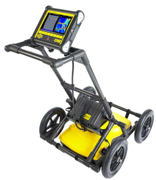
Our LMX100™ sensors and software complement the locator’s toolkit, offering a more complete picture of underground infrastructure. With a simple, easy-to-use interface, it also offers the perfect balance of penetration depth and high resolution for precise location determination.
The LMX100 is a ground penetrating radar (GPR) system manufactured by Sensors & Software Inc. It is designed for non-destructive subsurface imaging, allowing users to visualize and map underground features and utilities. Here’s an overview of the LMX100 GPR system:
- Principle of Operation: The LMX100 operates based on the principle of sending radar pulses into the ground and analyzing the reflected signals to create images of subsurface features. It emits electromagnetic waves into the ground and detects the signals reflected back from underground structures, utilities, and anomalies.
- High-Resolution Imaging: The LMX100 produces high-resolution images of the subsurface, allowing users to visualize features such as pipes, cables, voids, rebar, utilities, and geological formations. The system provides detailed information about the depth, size, and location of these features.
- Real-Time Data Acquisition: The LMX100 provides real-time data acquisition and processing capabilities, allowing users to view live radar images of the subsurface directly on the system’s display screen. This feature enables immediate on-site analysis and interpretation of the data.
- User-Friendly Interface: The LMX100 features a user-friendly interface with intuitive controls and menu navigation, making it easy for operators to configure settings and interpret the radar data. It typically includes software for data processing and interpretation.
- Versatile Applications LMX100 GPR: The LMX100 is suitable for a wide range of applications, including utility locating, infrastructure assessment, geological mapping, archaeological surveys, environmental studies, and concrete inspection. It can be used in various ground conditions, including soil, sand, gravel, asphalt, and concrete.
- Portable Design: The LMX100 is designed to be portable and easy to transport, allowing for flexible deployment in the field. It is typically housed in a rugged and durable enclosure that protects the system’s components from dust, moisture, and mechanical shock.
- Integrated GPS: Some models of the LMX100 may feature integrated GPS functionality, allowing users to geo-reference the detected subsurface features and create accurate maps of underground infrastructure.
- Battery-Powered Operation: The LMX100 is powered by internal batteries, providing convenient and portable operation in the field. The system typically offers long battery life to support extended use during subsurface imaging tasks.
Other products in category GPR