Description
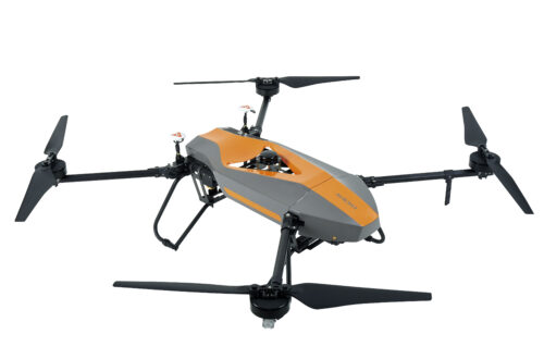
Aircraft Systems CHC P560 in Uzbekistan, Tashkent
P560 owns the one-piece body and only needs 8 min to complete the whole UAV assembly. The maximum takeoff weight (MTOW) could be 20 kg and the maximum flight (endurance) time could be up to 50 min. Embedded frequency hopping technology gives the communication line high immunity against interference and jamming.
Additionally, GPS positioning can simplify the UAV operation and ensure the excellent flying performance even in harsh environment.
P560 can carry sensor systems such as HD color camera (SLR camera), airborne lidar (CHC AS100), oblique photography system (CHC AP5600), multiple and hyperspectral systems to give diverse equipment selection to the user.
The CHC P560 is an unmanned aircraft system (UAS) designed for various aerial applications, including surveying, mapping, surveillance, agriculture, and inspection. As an unmanned aircraft system, it typically consists of the following components:
- Aircraft Platform Aircraft Systems CHC P560: The P560 unmanned aircraft serves as the aerial platform for carrying sensors, cameras, and other payloads. It’s designed for stability, maneuverability, and endurance to meet the demands of different missions.
- Payload Integration Aircraft Systems CHC P560: The P560 can carry various payloads, including cameras, multispectral sensors, LiDAR systems, thermal imagers, or other specialized equipment based on the requirements of the mission. Payloads are typically integrated into the airframe and controlled remotely.
- Flight Control System Aircraft Systems CHC P560: The P560 is equipped with a flight control system that manages navigation, stabilization, and communication between the aircraft and the ground control station. It may feature autonomous flight capabilities, waypoint navigation, and real-time telemetry for monitoring flight parameters.
- Ground Control Station (GCS) Aircraft Systems CHC P560: The GCS serves as the command center for controlling the P560 during flight operations. It includes a control interface, telemetry system, and communication links for sending commands to the aircraft and receiving telemetry data and video feeds.
- Remote Sensing and Imaging: The P560 is equipped with sensors and imaging systems for capturing aerial data and imagery. This may include high-resolution cameras for photogrammetry, multispectral sensors for agriculture applications, LiDAR for terrain mapping, or thermal cameras for inspection and surveillance.
- Data Processing Software: The P560 typically comes with software for mission planning, data acquisition, and post-processing of captured imagery and sensor data. This software may include features for generating maps, 3D models, orthomosaics, and other geospatial products from aerial data.
- Regulatory Compliance: Operators of the P560 must comply with relevant regulations and guidelines for unmanned aircraft operations, including registration, licensing, airspace restrictions, and safety protocols. Compliance ensures safe and legal operation of the UAS in various environments.
- Rugged Design: The P560 is designed to withstand outdoor conditions and rugged environments encountered during aerial missions. It may feature durable construction, weather-resistant materials, and redundancy systems for increased reliability.
- Versatile Applications: The P560 can be used for a wide range of applications, including aerial surveying and mapping, precision agriculture, infrastructure inspection, environmental monitoring, disaster response, and public safety operations.
Other productes in category Unmanned Aircraft Systems