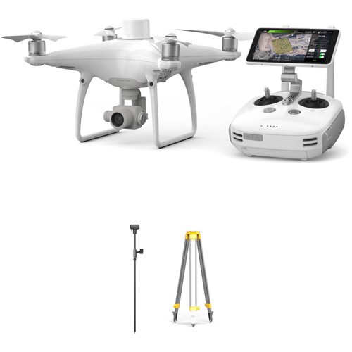
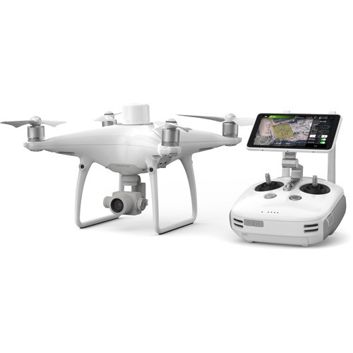
DJI PHANTOM 4 RTK Drone

DJI PHANTOM 4 RTK

The Phantom 4 RTK drone is an industrial quadcopter designed for aggregating precise map data. Thanks to the ultra-modern RTK module, the drone can receive information with an accuracy of 1 cm. Data is transmitted in real time with the smallest error.

Purpose: Cartography and geodesy
Type: Quadcopter
Gimbal type Camera compatibility: Built-in camera: 1” CMOS; Effective pixels: 20 MP
Gimbal installation Camera placement options:
Dimensions when unfolded:
Dimensions when folded: 350 mm diagonally
Weight (including batteries and propellers): 1391 g
Batteries: One (PH4)
Battery capacity / Battery weight: 5870 mAh / 468 g
Battery charging time: 62 min
Maximum take-off weight:
Maximum payload:
Navigation / Positioning systems: GNSS: GPS+BeiDou+Galileo Asia)+RTK; GNSS: GPS+GLONASS+Galileo other regions)+RTK
Sensors / Sensors:Dual IMU; Dual GNSS
Maximum flight time (up to): 30 min
Maximum speed (up to): S: 72 km/h; P: 50.4 km/h; A: 57.6 km/h
Maximum speed of ascent – descent (up to): 6 m/s – 5 m/s
Maximum wind resistance: 10 m/s
Control panel:GL300N
Video output ports: USB, HDMI
Video transmitter: OcuSync 2.0
Multi-user mode / UAV capabilities: Mode for controlling multiple drones (up to five)
Operating frequency: 2.400 GHz to 2.483 GHz; 5.725 GHz to 5.850 GHz
Maximum distance: Up to 7 km (FCC) and 5 km (CE)
Maximum altitude above sea level: 6000 m
Operating temperature: 0 ºC to 40 ºC
Engine model:DJI 2313S
Propeller model:DJI 9450S
Obstacle detection:Front/rear (binocular optical sensors): 0.7-30 m; Side (infrared): 0.2-7 m; Down (VPS): 0.7-30 m.
Programs: DJI GS RTK (Android); DJI FlightHub (Browser)
Features: External RTK network or mobile station D-RTK v2; 4G RC connection <> RTK; RTK pos. Accuracy: Horizontal 1cm+1ppm, Ver. 1.5cm+1ppm; Mapping accuracy: 720p real-time or 4K PPK (no GCP)
Features: GSD (distance between soil samples): 100 m: 3cm; 200m: 6cm; TimeSync – center CMOS position; Data is recorded in EXIF and XMP; Intelligent battery; Mobile SDK

Description

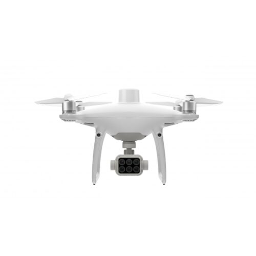
DJI PHANTOM 4 RTK in Uzbekistan, Tashkent

The last word in cartography and geodesy

True mapping and surveying professionals will appreciate this compact, incredibly smart and highly accurate drone. Its module provides the best data and high-performance image processing system along with other capabilities making it an ideal choice for surveying and mapping work.

Highlights of the Phantom 4 RTK

  • Location determination systems are integrated, this ensures continuous flight of the drone in areas with poor signal. The system can record and store information for the purpose of processing kinematics.
  • The Phantom 4 RTK drone is equipped with Time Sync technology, which guarantees a stable connection between the controller, RTK module and the drone camera.
  • The technology receives the most accurate metadata, which it sends to the CMOS sensor, the quality of which is 20 MP.
  • High quality images can provide a ground resolution of 2.74 centimeters from a 100 meter height. Photo and video data in HD is transmitted over a distance of 7 kilometers. The received data can be viewed in the proprietary GS-RTK application.

Mapping with incredible accuracy

DJI is constantly improving its technology, and the introduction of the Phantom 4 RTK marks the next step in the development of similar technologies and quality standards in the field of surveying. The drone’s equipment helps the user obtain information in which the accuracy of the parameters is verified down to the centimeter. In this case, the drone’s flight route is built according to the most optimal scheme DJI PHANTOM 4 RTK.

Centimeter-accurate positioning system

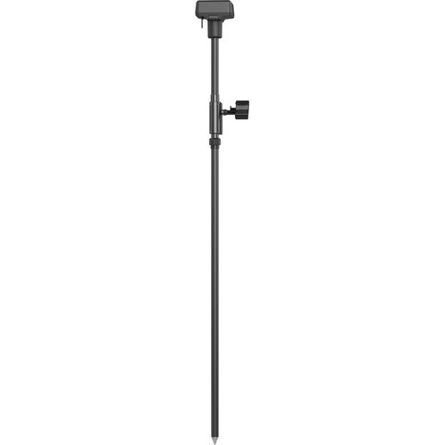
Phantom 4 RTK integrates an RTK module, delivering centimeter-level precision data in real time and with minimal absolute image metadata error. In addition to optimized flight safety and accurate data collection, the Phantom 4 RTK stores position data from satellites to be used for post-processing (PPK) data, which can be conducted using the DJI Cloud PPK* service. Use Phantom 4 RTK in any workflow with the ability to connect to a D-RTK 2 High Precision GNSS or NTRIP (Network RTCM over Internet Protocol) mobile station positioning system using a 4G dongle or WiFi hotspot DJI PHANTOM 4 RTK.

Accurate data with TimeSync

DJI created the TimeSync system to provide constant communication between the flight controller, camera and RTK module. TimeSync captures centimeter-level positioning data using images with precise metadata DJI PHANTOM 4 RTK.

Precise image processing system

Thanks to the 1-inch CMOS sensor, image quality reaches 20 megapixels. The mechanical shutter prevents blurred images during shooting, allowing you to perform mapping and data collection tasks perfectly. Thanks to its high resolution, Phantom 4 RTK can achieve a ground resolution (GSD) of 2.74 cm at an altitude of 100 meters. Every Phantom 4 RTK’s camera lens goes through a calibration process to ensure the data is as accurate as possible. Distortion settings are stored in the metadata of each image, allowing post-processing software to be adjusted individually for each user DJI PHANTOM 4 RTK.

Image processing accuracy

Phantom 4 RTK inherits the best from its predecessors: a one-inch CMOS sensor with a resolution of 20 megapixels, allowing you to capture high-quality frames, a mechanical shutter that prevents blurry frames when shooting on the move and other advantages . Therefore, no matter what tasks you solve – creating maps or simply collecting the data you need – everything will be done perfectly. The following technologies will help with this:

With a built-in flight planning application (GS RTK) and a simple RTK data collection method (RTK network or D-RTK 2 mobile station), pilots have a complete solution for any surveying, mapping process or checks – straight out of the box.

GS RTK Application

The DJI GS RTK app, with its on-screen Remote Controller, allows users to control the drone in two modes: Photogrammetry and Waypoint Flight. With a built-in screen, pilots can clearly view and plan their missions on the ultra-bright 5.5-inch HD display. The functionality of the application allows you not only to plan a flight and control the operation of the camera, but also to warn the pilot about adverse weather conditions.

The DJI Phantom 4 RTK (Real-Time Kinematic) Drone is a professional-grade UAV (Unmanned Aerial Vehicle) specifically designed for surveying, mapping, and other precision applications that require high-accuracy positioning data. Here are the key features and functionalities of the DJI Phantom 4 RTK:

  1. RTK Positioning System: The drone is equipped with a high-precision RTK GNSS (Global Navigation Satellite System) module, providing centimeter-level positioning accuracy in real-time. This allows for precise aerial mapping and surveying applications.
  2. Integrated RTK Module: Unlike the standard Phantom 4 series, the RTK version comes with an integrated RTK module that works in conjunction with ground-based reference stations to provide accurate positioning data.
  3. High-Resolution Imaging: The Phantom 4 RTK features a high-resolution camera with a mechanical shutter, capable of capturing sharp and detailed images suitable for mapping and photogrammetry applications.
  4. Post-Processing Kinematics (PPK) Option: In addition to real-time positioning, the Phantom 4 RTK also supports post-processing of positioning data using PPK technology. This allows for further refinement of accuracy by processing data after the flight mission.
  5. TimeSync System: The drone features DJI’s TimeSync system, which aligns the flight controller, camera, and RTK module to ensure accurate positioning data and image capture timestamps, essential for precise mapping and surveying.
  6. Flight Planning Software Compatibility: The Phantom 4 RTK is compatible with various flight planning software, including DJI Terra and third-party applications, enabling users to plan and execute automated survey missions with ease.
  7. Built-in Obstacle Avoidance: The drone is equipped with obstacle sensing and avoidance sensors, helping to prevent collisions during flight and ensuring the safety of the aircraft and surrounding environment.
  8. Long Flight Time: The Phantom 4 RTK offers an extended flight time compared to consumer-grade drones, allowing for efficient coverage of large survey areas without frequent battery changes.
  9. Mobile Connectivity: The drone can be operated using a compatible mobile device running the DJI GS RTK app or other supported software, providing real-time monitoring of flight parameters and mission progress.
  10. Data Export Compatibility: The Phantom 4 RTK supports various data export formats, including industry-standard formats for GIS (Geographic Information System) and CAD (Computer-Aided Design) software, facilitating seamless integration into existing workflows.

Overall, the DJI Phantom 4 RTK Drone is a powerful tool for professionals in fields such as land surveying, construction, agriculture, and infrastructure inspection, offering high-precision mapping and surveying capabilities with ease of use and reliability.

Other prodcuts in category  Unmanned Aircraft Systems